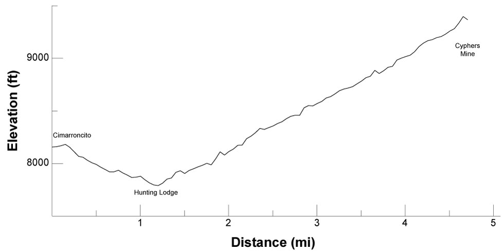

| Distance | 4.68 mi |
| Elevation Gain | 1,777 ft |
| Elevation Loss | 566 ft |
| Hiking Time | 3:00 |
| Starting Elevation | 8,156 ft |
| Ending Elevation | 9,367 ft |
| Min Elevation | 7,789 ft |
| Max Elevation | 9,397 ft |
From Cimarroncito, hike south along a broad valley on an easy trail with views across the valley to the west of 10,475-foot Cimarroncito peak. At about 1-1/4 miles pass Waite Phillips' Hunting Lodge, then turn west, up the Cimarroncito creek valley.
In about 1/2 mile, 1-3/4 miles from Cimarroncito, take the northern trail up the North Fork of Cimarroncito Creek. The trail becomes a bit rougher, but also more picturesque, as you progress. As you continue hiking west, you gain elevation while the geology around you gets older.
Just past the 4-1/2 mile point, cross the creek and arrive at Cyphers Mine.
At about 1-1/4 miles pass Hunting Lodge. Stop for a cabin tour.
Purified water is available at Cimarroncito, Hunting Lodge, and Cyphers Mine. Water from Cimarroncito Creek is available between Hunting Lodge and Cyphers Mine.
Itinerary 1, day 4
Itinerary 25, day 7
Cimarroncito: rock climbing, rappelling, boulder wall, and showers
Hunting Lodge: cabin tour
Cyphers Mine: blacksmithing, gold panning, mine tour, and Stomp