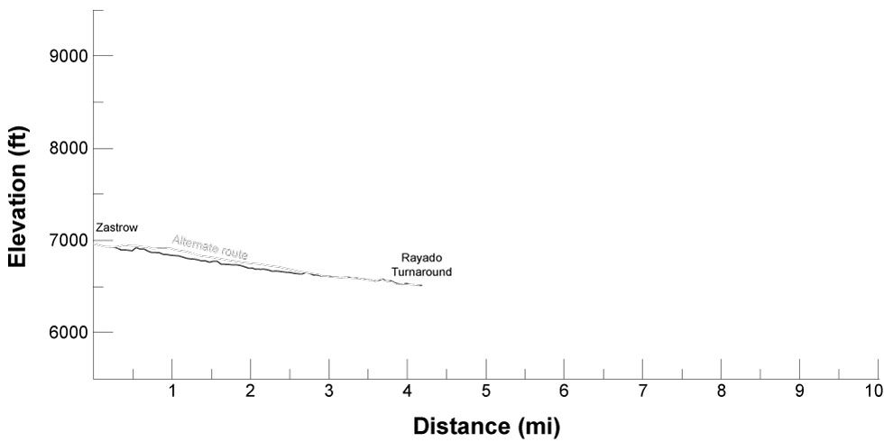

| Distance | 4.2 mi |
| Elevation Gain | 120 ft |
| Elevation Loss | 567 ft |
| Hiking Time | 1:43 |
| Starting Elevation | 6,959 ft |
| Ending Elevation | 6,512 ft |
| Min Elevation | 6,512 ft |
| Max Elevation | 6,959 ft |
An easy walk along mostly dirt roads across Philmont pasture land. The suggested route avoids the more traveled road but adds two, sometimes dicey, creek crossings. Take your time and don't be afraid to get a little wet.
Enjoy the views across the plains to the east.
Water is available at Zastrow and Rayado TA. The suggested route crosses Rayado Creek 3 times, the alternate route crosses once.
The alternate route takes you northeast to Zastrow Turnaround, then along the "main" dirt road between NM Highway 21 and the turnaround for almost 2 miles — the same road the Philmont buses will be driving to drop off other crews. It does avoid a couple of creek crossings, but the road walk is a significant negative.
| Distance | 4.17 mi |
| Elevation Gain | 56 ft |
| Elevation Loss | 503 ft |
| Hiking Time | 1:34 |
Itinerary 2 - day 12
Itinerary 11 - day 12
Itinerary 21 - day 12
Itinerary 22 - day 12
Zastrow: staffed camp with land navigation, geocaching, Dutch oven dessert, and Rededication to Scouting ceremony. Showers may be available.
Rayado TA: trailhead with Kit Carson Museum including blacksmithing and tomahawk throwing.